Iguassu River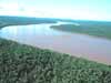
Iguassu River is about 1,000 km. or 625 miles long (new date). It springs at 900 meters above sea level from the Atlantic coast, of southeastern Brazil and flows in a generally westward direction to its confluence with the Parana River. The Iguassu River forms part of he boundary between Argentina and Brazil. About 23 km or 15 miles before the junction, are the great Iguassu Falls between 180 and 100 metres above sea level.
To know about the water level at the Iguassu Falls click on the last green button on the left side of the map, hotel cataratas: Iguacu river basin.
Down below you will find more information about the Iguassu River.
Origin of the name IguassuThe original name of the Iguassu in Brazil was with double ss. In 1970 Portugal decided to make some changes in the Brazilian language and the Brazilians accepted. After that they start to spell it with (Iguacu). Still lots of people prefer the old name.
In Argentina they spell it with z (Iguazu). In Guarani language is Y-guazu.
Guarani is the name of the ethnic indian who have lived in the area for more than 6.000 years.Ã?Â
The Iguassu River in numbers:DatesLength: approximately 1000 km
Annual medium average flown: 1.400 m3/s
Annual maximum average flown: 2.500 m3/s
Annual minimum average flown: 1.300 m3/s
The biggest floods at Iguassu FallsFlood in 1936 approximately 25.000 m3/s
Flood in May 1983 approximately 22.000 m3/s
Flood in July 1983 approximately 33.000 m3/s
Flood in May 1992 approximately 36.000 m3/s
Flood in May 1995 approximately 27.500 m3/s
Flood in May 2005 approximately 19.000 m3/s
Flood in June 9th, 2014 approximately 28.000 m3/s
Note: some literature suggest higher numbers
We had many small floods through the years but most of them were less than 19,000 m3/s.
1 cubic meter of water (m3) equal to 1,000 liters or 264 gallons (approximately).
m3/s stands for cubic meters per second.
The lowest level of water at the Iguassu FallsThe lowest level was in 1978 approximately 90 m3/s (approximately 6 months without rain). In 1967 there was also a long period without rain (8 months). Before that in 1951 the water level was also very low. In June, July and August of 2006 the water also was very low.
More Information about the Iguassu RiverRiver formationIt begins on the Serra do Mar, on the high plains of Curitiba (capital od the State of Parana) at 900 meters above sea level and runs inland passing through the Serra Geral forming sand banks on its way. The Iguassu River it is formed with the joining o two different rivers, Irai and Atuba. Both are located on the east side of Curitiba, capital of Parana State. The Iguassu River is a tributary of the Parana River and it is the biggest river in the State of Parana in Brazil.
Iguassu River Basin25 40 48" S; 54 26 6" W
The drainage area of the basin between Brazil and Argentina is 72,800 km2
70% of the Iguassu basin in Brazil is located in the State of Parana and 30% in the State of Santa Catarina. This make the total 70.800 (this represents 98.05 % of the basin).
The Iguassu basin in Argentina (Province of Misiones) is 1.837 km2 or only 1.95% of the area of the basin.
Main tributaries of the Iguassu River
Sources that form the first tributaries of the Iguassu River are in the municipality of Piraquara on the Serra do Mar. The name of the little stream is Irai. The Irai River flows through the city of Piraquara and Pinhais (districts of Curitiba) into which much sewage and garbage are discharged.
The Atuba River it is also one of the tributaries of the Iguassu River. The source is at the municipality of Colombo. It runs through Curitiba for about 23 km on the northern part of the city and joining another stream called Arroio Cachoeira. This river also receives a lot domestic sewage and garbage.
NavegationOnly part of the river it is navigable. Near Curitiba and also in the Porto Amazonas and Uniao da Vitoria. It is not navigable from Uniao da Vitoria (west of Serra Geral) until reach the Parana River. On the way the river flows on the steps left by the basalt rocks (volcanic layers of lava deposited over 120 million years ago).
Hydro plants on the Iguassu River BasinThe� natural difference level of the Iguassu River, 900 meters at the its source to the conjunction with the Parana River (110 meters) allowed for the construction of 5 dams.
1 -Â Hydropower plant of Foz do Areia 1.260.000 kw;
2Â - Hydropower plant of Manguerinha 1.260.000Â kw;
3 - Hydropower plant of Caxias 1.240.000 kw;
4 - Hydropower plant of Salto Santiago 1.332.000 kw;
5 - Hydropower plant of Salto Osorio 1.050.000 kw;
6 - Hydropower plant of Baixo Iguacu 350.000 KW.
Polution in the Iguassu RiverAs the Iguassu River flows through an area of more than two million inhabitants (Curitiba), in some sections is close to becoming a "dead river". This is because a lot of domestic sewage and garbage that are discharged into it. Mercury, manganese and some industrial waste also pollute it.

)
)